Point-cloud data from 3D laser-scanning is a major digitalization and technology triumph for the Surveying and AEC sectors. Design and construction point-cloud data can be delivered quickly and accurately from onsite into workflows for BIM and digital twin models.
At Bricsys, our CAD design and modeling tools have interoperable, third-party and advanced features. This gives users the capability to take the point-cloud data through CAD-based BIM and complex 3D workflows to create the deliverables in a shareable IFC format.
In part three of this blog series, we look at ways CAD users can deploy powerful Scan-to-BIM data. And look out for other CAD methods on Scan-to-TIN surface and Scan-to-Plan with point-cloud 3D technologies.
Let’s look at Scan-to-BIM.
Scan-to-BIM: Intelligent tools to turn a point-cloud into an accurate 3D Model
BricsCAD BIM can turn your 3D laser scans into 3D geometry and automatically add classifications to turn them into a Building Information Model (BIM).
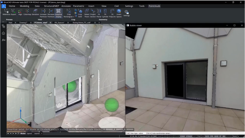
The Fit Planner tool can automatically create 3D surfaces or solids by selecting points from a point-cloud. BricsCAD gives you the option to select more points for low-resolution point-clouds, so the geometry generated is more accurate.
These tools can also be used in the bubble view, clicking to create walls, floors and ceilings.
Quickly create openings like doors or windows, with Scan-to-BIM tools
The Select Opening option will create a polyline around openings like doors or windows so that you can extrude these polylines to create gaps in your surfaces. Once done, you'll have 3D surfaces with gaps to represent openings.
Toggle between bubble views and switch point-clouds on or off to show the solids you create
The Automatic Stitching options can create complete solids rather than surfaces, so you can have a representation of the room volume. You can toggle between bubble views to jump straight to the view where you want to create spaces, and the areas don't have to be perfectly rectangular. When working on irregular areas, or maybe areas not perfectly aligned, BricsCAD BIM lets you use Fit Planner to stitch different components into a solid. Once you have the 3D geometries you need, you can switch off the section clip and switch off the point-clouds showing the solids you've just created.
BIM tools to create a building from a set of solids
You can use the BIM Invert Spaces command to create a building from a set of solids by inserting slabs, walls and roofs. You can set thickness parameters, for example to bottom slabs, top slabs and inner slabs, with the tolerances determining whether the geometry should be defined as parallel or co-planar.
You can also create individual walls per floor or create a single wall shell. And when you're happy with your choices, BricsCAD BIM will create a correctly classified model with walls, roofs and slabs. You can even add more information within the BIM Properties Panel.
Export model to IFC through Scan-to BIM workflows
Once ready, you can export your model to IFC to use within a BIM workflow. When opening the model in a viewer, the model contains all of its associated intelligence and information, ready to go.
So BricsCAD BIM will help you minimize reworks on designs and reduce site visits by using your point-cloud data as a base for creating a digital twin of your project site.
Discover the BricsCAD difference
With BricsCAD, surveyors, architects and engineers can take point-cloud data from 3D scanning for collaborations working on detailed and complex 3D and BIM models.
The intelligent commands accelerate point-cloud workflows, and our partner apps provide an open platform to extend BIM functionality, with deliverables such as quantity take-offs for MEP engineers, manufacturers and contractors.
To discover more about difference you get with the BricsCAD, go to our innovative solutions for Land Surveyor.
And to review more tools and commands in CAD for your sectors and roles, explore how to build better workflows with BricsCAD’s interoperable, intuitive and powerful solutions. We can’t wait for you to join and connect with the Bricsys community.

